Case study | Mining and resources | Retrieval-augmented generation | Reference design
Key findings
- Exploration decisions rest on data that already exists. Geological maps, geophysical and geochemical surveys, earlier drilling and tenure records are mostly collected before a rig arrives, and they are scattered across formats, decades and organisations.
- Retrieval-augmented generation fits this problem because the questions are specific and the answers must be traceable. A model that answers only from retrieved, cited passages is easier to audit than one that answers from memory.
- The bottleneck is provenance, not generation. Without coordinates, dates, methods and confidence on each record, the system retrieves fluently and misleads.
- A qualified geologist stays in the loop. Reporting codes place responsibility on a named competent person, and a knowledge system should support that person, not replace the sign-off.
The situation: decisions made on scattered evidence
A company exploring for minerals decides where to spend its most expensive money, which is drilling. Before it drills, it builds a case from evidence gathered at lower cost: published geological maps, airborne and ground geophysical surveys, soil, stream-sediment and rock-chip geochemistry, satellite imagery and elevation models, records of earlier exploration on the same ground, and the legal status of the land. Public geological surveys publish much of this. Earlier operators left reports, logs and assays in formats that range from structured databases to scanned paper.
The practical problem is not the lack of data. It is that a geologist assembling a target case spends days finding, reading and reconciling it. The relevant fact sits in a footnote of a report from decades ago, in a grid whose coordinates use an older datum, or in a tenure record that changed last year. Two geologists answering the same question can reach different conclusions because they found different pages.
This study presents a reference design for a knowledge system that makes that evidence searchable, cited and comparable. The author’s own working materials do not describe a mining engagement. The design therefore draws on public standards and public geological survey practice. It is a reference design, and nothing here claims a deployment or a result.
The task: stand up the ecosystem for mining data points
The design question was how to use retrieval-augmented generation to stand up an ecosystem for mining data points, starting from the data points typically used to judge a prospect before any drilling is done. That gave two jobs: define what evidence matters, and define the machinery that makes it usable.
What evidence matters before drilling
Public sources agree on the main families of pre-drill evidence. The United States Geological Survey describes its mineral resource assessments as estimates of the location, quantity and quality of known and undiscovered mineral resources. Its Earth Mapping Resources Initiative funds geological, geophysical, geochemical and lidar data acquisition in areas with potential for critical minerals. Its geophysical mapping work in the southern Midcontinent notes that where geology is concealed under sedimentary cover, conventional surface mapping is poorly suited and subsurface mapping with geophysics is required, with interpretation supported by drill core where it exists.
The JORC Code, a widely used reporting standard, gives a parallel view from the reporting side. It lists examples of exploration results as outcrop sampling, assays of drill hole intersections, geochemical results and geophysical survey results. Its Table 1 checklist covers sampling techniques, data spacing, location of data points, quality of assay data and laboratory tests, mineral tenement and land tenure status, exploration done by other parties, geology, and other substantive exploration data such as groundwater, geotechnical and rock characteristics, and potential deleterious substances.
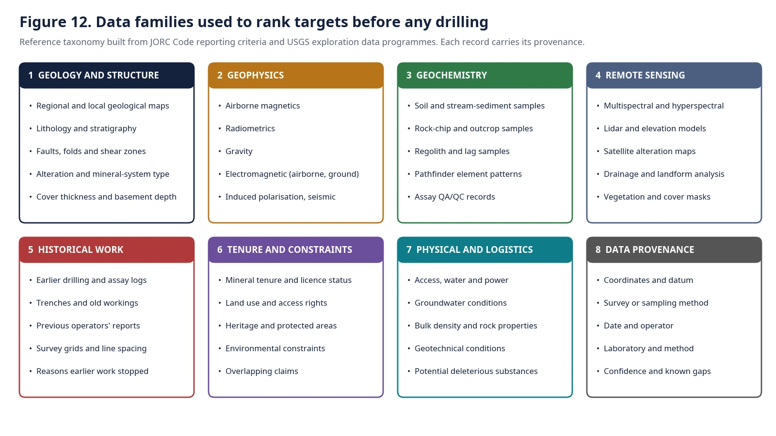
Putting these together gives eight data families (Figure 12). The table below lists the typical data points in each and what they inform. It is a reference taxonomy. A qualified geologist should adapt it to the commodity and deposit style at hand.
Scroll horizontally to view all columns.
| Family | Typical data points | What it informs |
|---|---|---|
| Geology and structure | Regional and local geological maps; lithology and stratigraphy; faults, folds and shear zones; alteration; mineral-system or deposit type; cover thickness and basement depth | Whether the rocks and structures that host the target deposit style are present, and how deep they sit |
| Geophysics | Airborne magnetics; radiometrics; gravity; airborne and ground electromagnetics; induced polarisation; seismic | Subsurface contrasts in magnetism, density, conductivity and chargeability, which help map concealed rocks and structures |
| Geochemistry | Soil and stream-sediment samples; rock-chip and outcrop samples; regolith and lag samples; pathfinder element patterns; assay quality-control records | Anomalies in target and associated elements that point to mineralisation nearby |
| Remote sensing | Multispectral and hyperspectral imagery; lidar and elevation models; drainage and landform analysis | Surface alteration, terrain and structure, and the cover that masks them |
| Historical work | Earlier drilling and assay logs; trenches and old workings; previous operators’ reports; survey grids and line spacing; why earlier work stopped | What has been tested, with what method and spacing, and where gaps remain |
| Tenure and constraints | Mineral tenure and licence status; land use and access rights; heritage and protected areas; environmental constraints; overlapping claims | Whether the ground can be explored and what limits apply |
| Physical and logistics | Access, water and power; groundwater; bulk density and rock properties; geotechnical conditions; potential deleterious substances | How hard and costly later steps are likely to be |
| Data provenance | Coordinates and datum; survey or sampling method; date and operator; laboratory and method; confidence and known gaps | Whether each record can be trusted and compared |
The last family is the one that makes the system work. Every record in the other seven needs it.
The action: a retrieval layer built around provenance
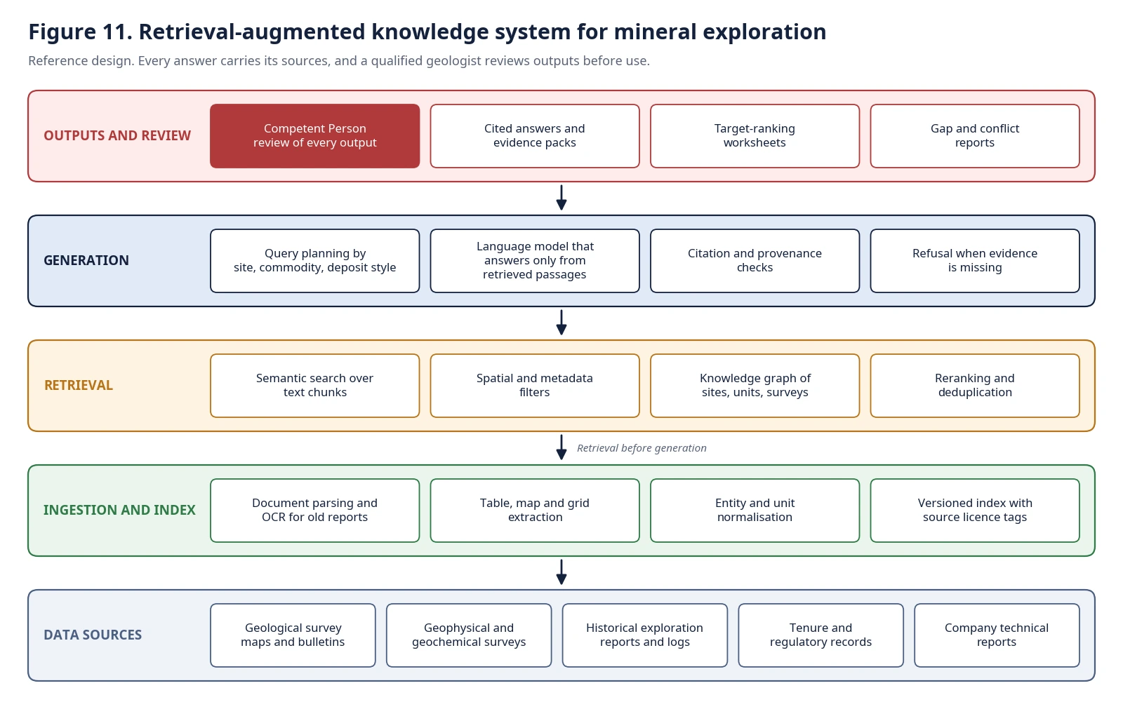
Retrieval-augmented generation, introduced in the research literature as a way to combine a language model with a searchable external memory, addresses a known weakness of models that answer from their parameters alone: limited ability to access precise knowledge and to show where an answer came from. In exploration, the cost of an untraceable answer is high, so the design treats citation as a requirement and not a feature (Figure 11).
Data sources and ingestion. The sources are geological survey maps and bulletins, geophysical and geochemical surveys, historical exploration reports and logs, tenure and regulatory records, and the company’s own technical reports. Ingestion handles the messy parts: parsing and optical character recognition for old scanned reports, extraction of tables, maps and grids, and normalisation of entities and units. A version history and a licence tag on each source keep the index honest about what may be used and for what.
Index and retrieval. Text chunks are indexed for semantic search. Spatial and metadata filters narrow results by area, commodity, survey type and date. A knowledge graph links sites, geological units, surveys and samples, so the system can answer relational questions such as which surveys cover this licence and what was found near this structure. Reranking and deduplication reduce noise, since the same report often appears in several places.
Generation under constraint. The language model answers only from retrieved passages. Query planning breaks a request into sub-questions by site, commodity and deposit style. Citation and provenance checks confirm that every claim maps to a source, and the system refuses to answer when the evidence is missing. A refusal is a useful output here, because it shows a gap that a field programme could fill.
Outputs and review. The system returns cited answers and evidence packs, target-ranking worksheets and reports of gaps and conflicts between sources. A competent person reviews every output before it informs a decision. Reporting standards require such a person to take responsibility, and the design keeps that accountability explicit.
The result the design aims for, and how to test it
This is a reference design, so the results are criteria and not outcomes. A deployment would be judged on four things.
Traceability. Every statement in an output links to a source passage with its provenance fields. A reviewer can audit any claim in seconds.
Coverage. The system reports what it knows and what it does not for a given licence: which survey types exist, at what spacing, and where data are missing.
Consistency. Two users who ask the same question receive the same evidence, with the same gaps stated.
Review time. The time a geologist needs to assemble an evidence pack for a prospect falls, and the quality of the pack, as judged by that geologist, does not.
The study offers no numbers for these. They have to be measured in a pilot against a baseline.
Risks and design responses
Old reports are noisy. Optical character recognition errors change grades and coordinates. The design flags low-confidence extractions and routes them to review.
Datums and units differ. A coordinate in the wrong datum places a sample in the wrong field. Normalisation and provenance fields prevent silent mismatches.
Models sound confident. Grounding, citation checks and refusal rules reduce the risk, and the competent person is the final control.
Licences and confidentiality vary. Some data are public and some are commercial. Licence tags travel with each record and filter retrieval.
Lessons for leaders
Start with provenance. Decide which fields every record must carry before ingesting anything.
Treat gaps as outputs. A system that tells a geologist what is missing is more useful than one that fills the space with plausible text.
Keep the sign-off human. Reporting standards assign responsibility to a qualified person. Build the system to support that person.
Pilot on one licence. Prove traceability and review time on a single area before scaling across a portfolio.
Recommendations
Choose one prospect and one commodity. Inventory its data across the eight families. Define the provenance fields. Ingest a small, well-understood subset, build retrieval with citation checks and run it against questions a geologist already knows the answers to. Compare the evidence pack with the one the geologist built by hand. Expand only when the pack matches.
Teams considering a knowledge system for exploration data can book a working session with the author through Topmate: https://topmate.io/raja_jeevan_kumar_maduri
Sources and method
This is a reference design. It does not describe a client engagement or report results. The data families and criteria draw on public sources: the JORC Code (2012 edition; https://www.jorc.org/docs/jorc_code2012.pdf); the United States Geological Survey, Assessing Mineral Resources (https://www.usgs.gov/programs/mineral-resources-program/science/assessing-mineral-resources); the USGS Earth Mapping Resources Initiative (https://www.usgs.gov/special-topics/earth-mri); the USGS geophysical mapping project for the southern Midcontinent (https://www.usgs.gov/centers/gggsc/science/geophysical-mapping-geologic-systems-host-critical-mineral-deposits-southern); and Lewis et al., Retrieval-Augmented Generation for Knowledge-Intensive NLP Tasks (https://arxiv.org/abs/2005.11401). The descriptions of what each geophysical and geochemical method informs reflect general geoscience practice and should be confirmed with a qualified geologist. Figures 11 and 12 are the author’s reference diagrams.